Northland drone inspections
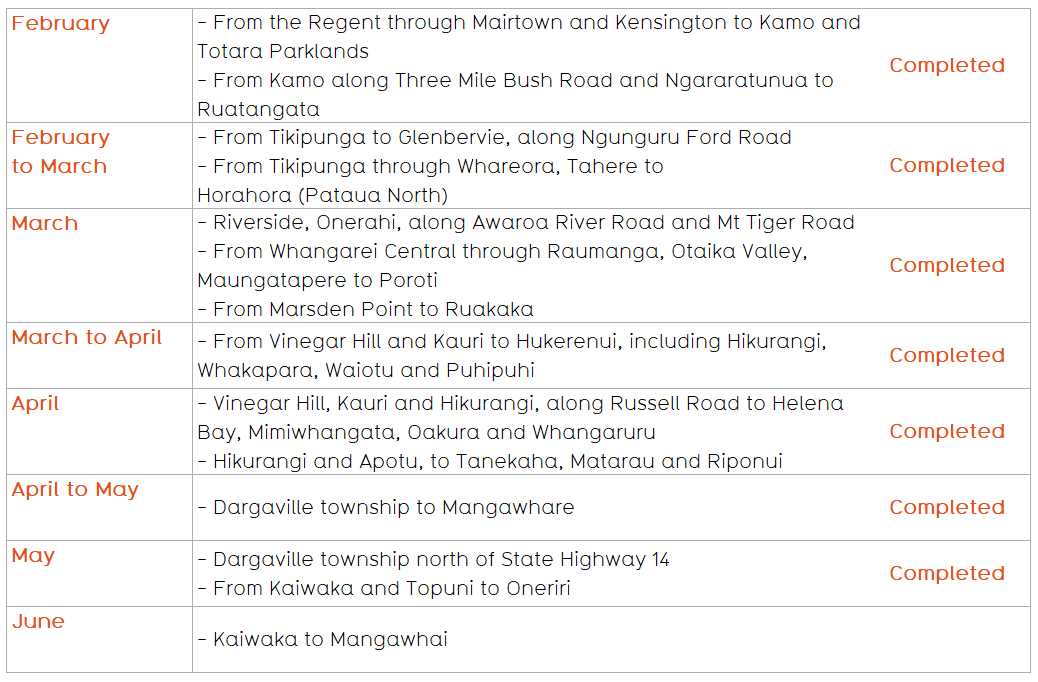
Drone inspection areas 2026
Drone and helicopter inspection FAQS
We’re using drones and helicopters to carry out faster, safer, and more precise inspections, enabling us to identify risks earlier to help ensure the reliability of our network. Extreme weather events, such as Cyclone Gabrielle, have highlighted the importance of proactive maintenance to minimise disruptions and maintain a reliable power supply.
To help us realise these benefits in a responsible way, Northpower ensures that all of its drone operators comply with the Civil Aviation Rules and are certified under Part 102 of those Rules.
Aerial surveys help us maintain a safe and reliable network by providing early identification of potential issues to help prevent power outages. They allow us to cover large areas quickly and reduce the need for crews to access challenging or hazardous locations. Aerial surveys also help identify vegetation growing too close to powerlines, which could potentially cause power outages and pose a fire risk.
Due to the different requirements of each inspection, the drones and helicopters operate at different heights. Drones will operate close to the overhead lines and equipment being photographed, while helicopters generally fly at approximately 1000 ft to minimise customer impact, but may need to fly lower at times to capture required data.
LiDAR uses lasers to scan the network, capturing millions of precise data points. These points are combined to create a 3D view of the surveyed area, including powerlines and surrounding vegetation. This allows us to assess conditions, ensure clearance requirements are met, and proactively address risks such as vegetation growing too close to electricity lines.
We understand that privacy is important. Our drones and helicopters focus only on our network equipment and the surrounding vegetation. The photography is only of poles, wires and trees, not of private homes or individuals. We also don’t take video footage.
The data captured by LiDAR creates a 3D view of the surveyed area, which includes powerlines and vegetation but not detailed personal property data from which an individual can be identified.
All work is carried out in accordance with the Privacy Act 2020. Any images or data that might identify a person are handled securely and used solely for inspecting and maintaining our electricity network.
In some cases, drone operators may also need to physically access your property to complete an inspection safely. If this is necessary, we’ll contact you in advance to arrange access.
We’ll share inspection schedules and locations on this webpage, and we’ll also notify local communities using a range of channels such as social media, letters, and email updates.
We appreciate your understanding as we carry out this essential work. These inspections are a critical part of maintaining a reliable and safe power supply for our community.
Please contact us on 0800 667 847 if you have any questions or concerns.
The LiDAR data collected is used to create a 3D map of the surveyed area. This, along with the photos that we will be taking of our equipment, helps us plan maintenance, ensure powerlines meet clearance standards, and identify vegetation risks.
The data we collect is handled securely and is for the primary purpose of inspecting and maintaining our assets. That purpose is lawful.
Data that incidentally records an individual will be blurred or edited out before being used by Northpower and will be handled in accordance with the Privacy Act 2020.
No, your power supply won’t be affected. The surveys can be completed safely without turning the power off.